Log in
All resources
Create a design
4,838 Free Artworks of Maps Of France
bibliothèque nationale de france
topographic map of france, 1864
lemercier & cie.
maps of spain by tomas lopez
maps from gallica
maps by tomas lopez
beschreibung der städt der welt - braun & hogenberg - btv1b52512111k
french-language maps
maps by alexis-hubert jaillot
robert cordier (engraver)
16th-century maps of the indian ocean
renaissance
topographic map of france, 1864
lemercier & cie.
topographic map of france, 1864
lemercier & cie.
topographic map of france, 1864
lemercier & cie.
topographic map of france, 1864
lemercier & cie.
topographic map of france, 1864
lemercier & cie.
topographic map of france, 1864
lemercier & cie.
topographic map of france, 1864
lemercier & cie.
maps of asia by jean-baptiste bourguignon d'anville
french-language maps
topographic map of france, 1864
lemercier & cie.
topographic map of france, 1864
lemercier & cie.
topographic map of france, 1864
lemercier & cie.
topographic map of france, 1864
lemercier & cie.
topographic map of france, 1864
lemercier & cie.
topographic map of france, 1864
lemercier & cie.
topographic map of france, 1864
lemercier & cie.
topographic map of france, 1864
lemercier & cie.
topographic map of france, 1864
lemercier & cie.
topographic map of france, 1864
lemercier & cie.
maps by alexis-hubert jaillot
old maps of toulouse
topographic map of france, 1864
lemercier & cie.
topographic map of france, 1864
lemercier & cie.
topographic map of france, 1864
lemercier & cie.
topographic map of france, 1864
lemercier & cie.
topographic map of france, 1864
lemercier & cie.
topographic map of france, 1864
lemercier & cie.
topographic map of france, 1864
lemercier & cie.
topographic map of france, 1864
lemercier & cie.
topographic map of france, 1864
lemercier & cie.
topographic map of france, 1864
lemercier & cie.
topographic map of france, 1864
lemercier & cie.
topographic map of france, 1864
lemercier & cie.
topographic map of france, 1864
lemercier & cie.
topographic map of france, 1864
lemercier & cie.
topographic map of france, 1864
lemercier & cie.
maps from traité de la police, bibliothèque nationale de france
first map of paris from traité de la police
maps of ancient italy by philipp clüver
maps of ancient sicily
maps from gallica
propaganda map
carte figurative de l'instruction populaire de la france
maps from gallica
maps made in the 15th century
old maps of france
maps of aire-sur-la-lys city walls
old maps of aire-sur-la-lys
18th-century maps of veneto
1700s maps of slovenia
1852 maps of france
old maps of isère
novus atlas sinensis
old maps of jiangxi
maps of spain by tomas lopez
1760 maps of spain
maps of paris from bibliothèque nationale de france
dheulland map of paris
maps of wissembourg by braun & hogenberg
maps of colmar by braun & hogenberg
maps of the ganges river
old maps of bengal
maps of dunkerque by braun & hogenberg
maps of bourbourg by braun & hogenberg
maps by pieter van der keere
maps by abraham ortelius
map of the circle of the rhineland by sanson
1730s maps of rhineland-palatinate
italia - di matteo greuter... - btv1b525056959
old maps of apulia
maps of spain by tomas lopez
1780 maps of spain
maps of spain by tomas lopez
1762 maps of spain
juan de la cruz cano y olmedilla
1755 maps of north america
1572 maps of africa
1570s maps of egypt
antoine-françois tardieu
jean-baptiste poirson
1880s maps of tunisia
maps from gallica
landais & oberthur
maps from gallica
maps in the library of congress
old maps of france
maps from géographie illustrée de la france et de ses colonies
orientalist painting
french-language maps of asia
1750s maps of asia
maps of tangier by braun & hogenberg
maps of asilah by braun & hogenberg
enceinte of philippe-auguste on old maps
1610s maps of paris
old maps of périgueux
1660s maps of france
maps of bourgogne (duchy) by gerardus mercator
1630s maps of france
maps of tangier by braun & hogenberg
maps of asilah by braun & hogenberg
maps of the course of the rhine by guillaume sanson
bibliothèque nationale de france
old maps of the bay of gibraltar
18th-century maps of gibraltar
synopsis universae philologiae
1710s maps of the world
18th-century maps of the black sea
maps by louis brion de la tour
maps by louis brion de la tour
french-language maps
maps of spain by tomas lopez
1761 maps of spain
old maps of gravelines
flandria illustrata
maps of spain by tomas lopez
1784 maps of spain
1786 maps of spain
maps of el bierzo
beschreibung der städt der welt - braun & hogenberg - btv1b52512111k
maps of mainz by braun & hogenberg
17th-century maps of xaintonge
maps by jodocus hondius
maps from the mechanical curator collection available to georeference
maps from the mechanical curator collection
beschreibung der städt der welt - braun & hogenberg - btv1b52512111k
maps of nîmes by braun & hogenberg
beschreibung der städt der welt - braun & hogenberg - btv1b52512111k
maps of dunkerque by braun & hogenberg
beschreibung der städt der welt - braun & hogenberg - btv1b52512111k
maps of groningen by braun & hogenberg
beschreibung der städt der welt - braun & hogenberg - btv1b52512111k
maps of heidelberg by braun & hogenberg
1780s maps of portugal
maps by tomas lopez
maps of spain by tomas lopez
1779 maps of spain
maps of spain by tomas lopez
old maps of lanzarote
map of the circle of the rhineland by sanson
1680s maps of rhineland-palatinate
maps of paris from paris musées
plan de roussel
maps by willem and johannes blaeu
1638 maps of asia
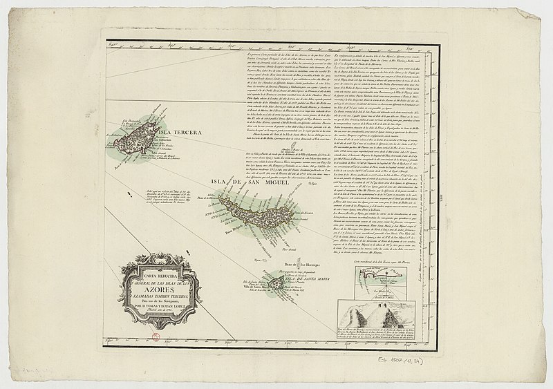
18th-century maps of the azores
1780s maps of portugal
old maps of the bahamas
lucayas
novus atlas sinensis
old maps of guangxi
map of the circle of the rhineland by sanson
1680s maps of rhineland-palatinate
cartes de franz schrader
1894 maps of france
pierre antoine tardieu
françois houiste
1690s maps of france
old maps of orléans
maps by jean-baptiste bourguignon d'anville
18th-century maps of western europe
old geological maps by jean-etienne guettard
jean étienne guettard
1762 maps of north america
maps by tomas lopez
maps of the ottoman empire by mercator-hondius
map
701 - 800 of 4,838
Next page
/ 49


![Lutetia or first plan of the city of Paris taken from Cesar, Strabo, the Emperor Julian and Ammiam Marcellin [Digitized still image] / By MLCDLM, Antoine Coquart](https://cdn.creazilla.com/illustrations/10001210581/lutetia-or-first-plan-of-the-city-of-paris-taken-from-cesar-strabo-the-emperor-julian-and-ammiam-marcellin-digitized-still-image-by-mlcdlm-antoine-coquart-sm.webp)
![Siciliae antiquae descriptio. 15; Corsicae antiquae descriptio. 16; Sardiniae antiquae descriptio / auctore Phil[ippo] Cluverio; Henry le Roy fecit, 1624](https://cdn.creazilla.com/illustrations/10001349357/siciliae-antiquae-descriptio-15-corsicae-antiquae-descriptio-16-sardiniae-antiquae-descriptio-auctore-phil-ippo-cluverio-henry-le-roy-fecit-1624-sm.jpg)


![Dvynkercke; Greveling; Borborch / [Georg Braun]](https://cdn.creazilla.com/illustrations/10000705529/dvynkercke-greveling-borborch-georg-braun-md.jpg)

![The Electoral Circle of the Rhine subdivided into all the Estates which compose it... / by Sanson, ,... Geometric Miles or Miles of Italy [30 = 12] common leagues of France, 1734](https://cdn.creazilla.com/illustrations/10001532968/the-electoral-circle-of-the-rhine-subdivided-into-all-the-estates-which-compose-it-by-sanson-geometric-miles-or-miles-of-italy-30-12-common-leagues-of-france-1734-sm.jpg)


![Topographic map of the south-western slope of Menez-haut / surveyed and drawn up [...] by AM Kamelin, 1849](https://cdn.creazilla.com/illustrations/10001387383/topographic-map-of-the-south-western-slope-of-menez-haut-surveyed-and-drawn-up-by-am-kamelin-1849-sm.webp)
![Plan of the circle battle between the U.S. ship "Keasarge," Capt. Winslow, and the Confederate cruiser "Alabama," Capt. Raphael Semmes, off the harbor [of] Cherbourg, France: forenoon of Sunday June 19th 1864., 19 June 1864](https://cdn.creazilla.com/illustrations/10000851176/plan-of-the-circle-battle-between-the-us-ship-keasarge-capt-winslow-and-the-confederate-cruiser-alabama-capt-raphael-semmes-off-the-harbor-of-cherbourg-france-forenoon-of-sunday-june-19th-1864-19-june-1864-md.jpg)


![Tingis, Lusitanis, Tangiara; Tzaffin; Septa; Arzilla; Sala / [Georg Braun]; [Franz Hogenberg], 1572](https://cdn.creazilla.com/illustrations/10000766715/tingis-lusitanis-tangiara-tzaffin-septa-arzilla-sala-georg-braun-franz-hogenberg-1572-md.jpg)


![Bargundia Ducatus. Miliaria communia 8 [=Om. 062; 1: 675 000 env] / Per Gerardum Mercatoré, Cum Privilegio, 1635](https://cdn.creazilla.com/illustrations/10000531668/bargundia-ducatus-miliaria-communia-8-om-062-1-675-000-env-per-gerardum-mercator-cum-privilegio-1635-md.jpg)
![Tingis, Lusitanis, Tangiara; Tzaffin; Septa; Arzilla; Sala / [Georg Braun]; [Franz Hogenberg], 1572](https://cdn.creazilla.com/illustrations/10000939898/tingis-lusitanis-tangiara-tzaffin-septa-arzilla-sala-georg-braun-franz-hogenberg-1572-sm.webp)